Overview
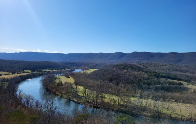
Shenandoah River State Park is a sprawling natural retreat in Virginia’s Shenandoah Valley. Situated along 5.2 miles of the South Fork of the Shenandoah River, the park boasts over 1,600 acres of rolling, mostly wooded land characterized by steep slopes and scenic vistas. The park’s prime location offers expansive views of Massanutten Mountain to the west and the iconic Shenandoah National Park to the east, creating a stunning backdrop of Blue Ridge beauty. Visitors are drawn to the shimmering river, a central feature that defines the park’s tranquil atmosphere and provides opportunities for peaceful reflection and water-based recreation.
The park is ideal for outdoor enthusiasts, featuring over 25 miles of multi-use trails for hikers, mountain bikers, and horseback riders. The trails range from easy riverside strolls to more challenging climbs leading to breathtaking spots like Culler’s Overlook. The Shenandoah River itself is a focal point for adventure, offering car-top boat launches for canoeists, kayakers, and anglers hoping to catch smallmouth bass. For those seeking an elevated thrill, the park also hosts zip line canopy tours, soaring high above the forest floor. With diverse camping options, Shenandoah River State Park serves as a perfect base camp for exploring the natural wonders of the entire valley region.
Shenandoah River State Park Map
Shenandoah River State Park - Things to do:
🏕 Camp in park campgrounds
🔥 Relax, unwind, and connect around a campfire
🥾 Hike scenic trails
🌅 View colorful sunsets
🌠 Gaze starlit skies
Shenandoah River State Park - Trip Review:
“The most memorable moment was watching my son enjoy nature, the new company, and fishing for the first time.” – Shenandoah River State Park 3-Day Adventure
Shenandoah River State Park: Tours and Trips
3 days  Campground
Hiking
Shenandoah River State Park, Daughter of Stars Drive, Bentonville, VA, USA
$215
(Adult)
Book now
Where is Shenandoah River State Park?
Shenandoah River State Park, is nestled in the scenic Shenandoah Valley of Virginia. The park's main entrance is located in the small town of Bentonville, Virginia. It is easily accessible off of U.S. Route 340. The park is strategically situated on the west side of the South Fork of the Shenandoah River, directly facing the Blue Ridge Mountains and offering stunning views of Massanutten Mountain to the west and the rolling hills of Shenandoah National Park to the east.
What is the weather like in Shenandoah River State Park?
Shenandoah River State Park enjoys a continental climate characterized by four changing seasons. Summers are warm and humid, with average high temperatures typically reaching the mid-to-upper 80s°F. Winters are cold, with average lows dropping into the mid-20s°F and the park receiving a modest amount of annual snowfall. Spring and Fall are arguably the most pleasant times to visit, offering milder, comfortable temperatures ideal for hiking. Precipitation is generally well-distributed throughout the year.
What flights go to Shenandoah River State Park? (Nearest airports)
The closest and most convenient major airport is Washington Dulles International Airport (IAD), located about 1 hour and 15 minutes away by car. For a potentially shorter drive, two regional options are available: the Shenandoah Valley Regional Airport (SHD) and the Charlottesville–Albemarle Airport (CHO). Ronald Reagan Washington National Airport (DCA) is also an option, located slightly farther away than IAD.
Is Shenandoah River State Park a national park?
No, Shenandoah River State Park is not a National Park; it is a Virginia State Park managed by the Virginia Department of Conservation and Recreation (DCR). However, there is confusion because it is located very close to, and offers views of, the much larger Shenandoah National Park, which is managed by the National Park Service (NPS). They are two separate, but geographically close, parks managed by different levels of government.
What outdoor activities are popular in Shenandoah River State Park?
The best experiences at Shenandoah River State Park revolve around its two defining features: the river and the mountainside trails. River recreation is a must-do, with the park offering a car-top launch for kayaking, canoeing, and fishing for smallmouth bass. You can bring your own boat or rent from local outfitters for a relaxing float or an exciting paddle trip along the South Fork of the Shenandoah. On land, the park boasts over 25 miles of multi-use trails for hikers, mountain bikers, and horseback riders, with varying levels of difficulty.